And now, after all of this hard work, of which there will be much much more to come, I have the first.........four or five days planned!!! Yes it's going to be a long winter yet. All of this planning makes me both anxious and tired. Sometimes the route planning gets overwhelming, and I feel like grabbing a big road atlas, packing the bike and leaving tomorrow. At the same time, I want to plan carefully enough so that we don't find ourselves in Strip Mall Land every 30 miles, sitting in traffic behind a filthy minivan full of suburban rats drinking plastic milk-shakes out of styrofoam cups. So I think all this map-looking, finding the roads with green dots next to them, will pay off.
So here is the first leg of our trip, which will take four or five days depending on how much sight-seeing we do. The first portion of our trip will bring us to Rhinebeck, NY. The plan so far is to attend the Rhinebeck Grand National Supermeet the weekend of June 11-13. Last year this was lots of fun, and we thought it would be a good jumping off point/event.
Here is my idea for the leisurely route to Rhinebeck, which is in the Hudson Valley:
View NH to Rhinbeck in a larger map
We'll probably leave the Meet late Sunday afternoon. From Rhinebeck, we'll take NY209 to the Delaware Water Gap, spending our first night in the Delaware State Forest. The next day will be a busy one. We're going to stop in Nazareth, PA, to see the Martin Guitar Factory. They have free guided tours, which sounds very fun! From Nazareth we'll make our way down to Micheax State Forest for our second night of camping. This is near Gettysburg, which we'll visit either that evening or the next morning.
View Pa Nazareth to Gettysburg in a larger map
Our next night will be somewhere along the Blue Ridge Parkway, depending on how many stops we make in the Appalachian mountains. We're going to take the Skyline Drive, then the Blue Ridge Parkway all the way to the end, in North Carolina.
View Gettysburg to the Blue Ridge Mountains in a larger map
Somewhere near the end of the Blue Ridge Parkway, we'll spend another night camping. I have a list of possible campgrounds, but I don't want to choose one now. Again, this will depend on how many stops we make, or if we do any of the short hikes along the parkway.
So far I am looking at 250-300 mile days. This figure will change as we enter different parts of the country. Oklahoma may be a 500 mile per day state, while the Sierra Nevada in California may
be a 100 mile per day region. A quick, superficial google maps search indicates that from NH to
California to Portland and back, avoiding highways, would be a 7,300 mile trip. So perhaps we should throw on a couple thousand miles worth of scenic byways and excursions. If we traveled 10,000 miles, averaging 250 miles per day, we would need 40 days to complete the whole trip. I think we're in good shape considering our eight available weeks!
A tool I didn't mention here but have in the past is the adventure rider's forum. I put up a few posts
asking for route suggestions, particularly in Eastern PA. The route in the google map above, going from Nazareth to Gettysburg, is one that was suggested to me by some folks on the forum. Some of the roads in that map were ones I had already considered, but it's great to get first-hand advice from motorcyclists
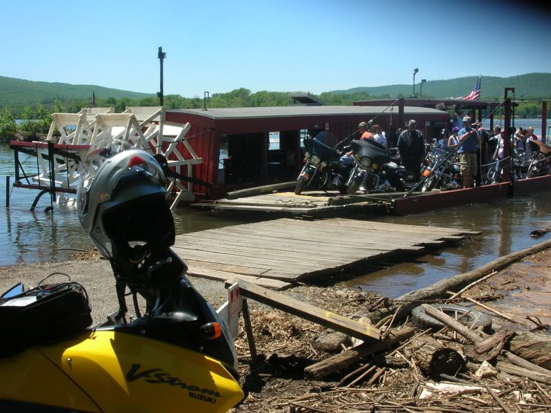
who are always seeking out good roads. And, one part of the route that I hadn't discovered is the
ferry crossing at Millersburg, PA. You cross the Sesquahana River on an old ferry boat. Looks like fun!It's stuff like this that will make this a great trip.
So here is the first leg of our trip, which will take four or five days depending on how much sight-seeing we do. The first portion of our trip will bring us to Rhinebeck, NY. The plan so far is to attend the Rhinebeck Grand National Supermeet the weekend of June 11-13. Last year this was lots of fun, and we thought it would be a good jumping off point/event.
Here is my idea for the leisurely route to Rhinebeck, which is in the Hudson Valley:
View NH to Rhinbeck in a larger map
We'll probably leave the Meet late Sunday afternoon. From Rhinebeck, we'll take NY209 to the Delaware Water Gap, spending our first night in the Delaware State Forest. The next day will be a busy one. We're going to stop in Nazareth, PA, to see the Martin Guitar Factory. They have free guided tours, which sounds very fun! From Nazareth we'll make our way down to Micheax State Forest for our second night of camping. This is near Gettysburg, which we'll visit either that evening or the next morning.
View Pa Nazareth to Gettysburg in a larger map
Our next night will be somewhere along the Blue Ridge Parkway, depending on how many stops we make in the Appalachian mountains. We're going to take the Skyline Drive, then the Blue Ridge Parkway all the way to the end, in North Carolina.
View Gettysburg to the Blue Ridge Mountains in a larger map
Somewhere near the end of the Blue Ridge Parkway, we'll spend another night camping. I have a list of possible campgrounds, but I don't want to choose one now. Again, this will depend on how many stops we make, or if we do any of the short hikes along the parkway.
So far I am looking at 250-300 mile days. This figure will change as we enter different parts of the country. Oklahoma may be a 500 mile per day state, while the Sierra Nevada in California may
be a 100 mile per day region. A quick, superficial google maps search indicates that from NH to
California to Portland and back, avoiding highways, would be a 7,300 mile trip. So perhaps we should throw on a couple thousand miles worth of scenic byways and excursions. If we traveled 10,000 miles, averaging 250 miles per day, we would need 40 days to complete the whole trip. I think we're in good shape considering our eight available weeks!
A tool I didn't mention here but have in the past is the adventure rider's forum. I put up a few posts
asking for route suggestions, particularly in Eastern PA. The route in the google map above, going from Nazareth to Gettysburg, is one that was suggested to me by some folks on the forum. Some of the roads in that map were ones I had already considered, but it's great to get first-hand advice from motorcyclists
who are always seeking out good roads. And, one part of the route that I hadn't discovered is the
ferry crossing at Millersburg, PA. You cross the Sesquahana River on an old ferry boat. Looks like fun!It's stuff like this that will make this a great trip.
Watch for more posts about route ideas, and if you have any, feel free to comment!
No comments:
Post a Comment